Tag Archives: national park

Hiking, history, and Harper’s Ferry

image

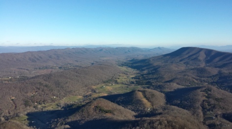
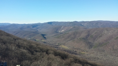
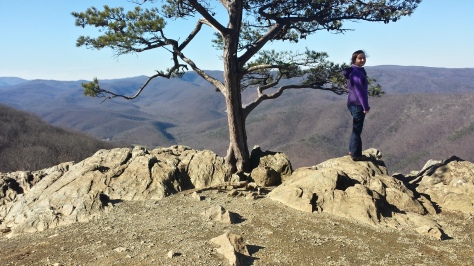
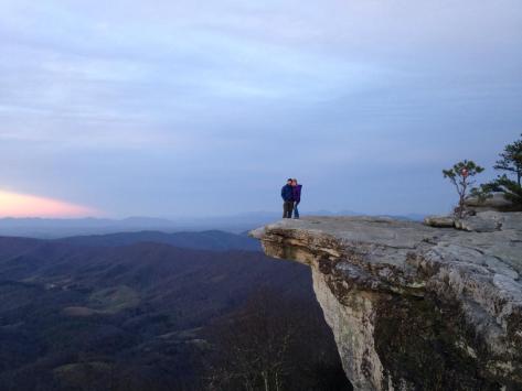
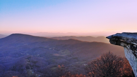
Surveying the layout of the town in front of us, surrounded on three sides by the Shenandoah and Potomac rivers, we reveled in how lucky we were to have the Maryland Heights overlook to ourselves on such a gorgeous day. From our perch on the rocks we could see the historic section of Harper’s Ferry, people running up and down the C&O Canal Towpath (see previous blog post under that name for more about it), and the green hue of the rivers as they converged and flowed as one towards Chesapeake Bay.
image

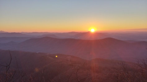
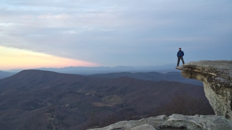
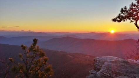
The night before, I had gone to visit one of my best friends from back home in Texas. He lives in a small town ten minutes west of Harper’s Ferry with his wife and dogs, which is nice considering the fact that I was expecting to know almost nobody when I decided to stay in Virginia after the Marine Corps. We planned on hiking the Maryland Heights trail to watch the sunrise from the overlook, but several snoozes of the alarm and a stop at Sheetz changed that. So at 8 am Cody, Orion (his dog) and I started up the trail.
image

Most people have only heard of Harper’s Ferry because of the abolitionist John Brown, who led a group of about 20 men to raid the local armory. There is a lot more history surrounding the town, though; during the War for Southern Independence Harper’s Ferry traded hands 8 separate times, and it has been stated by several historians as the site of Gen. Thomas “Stonewall” Jackson’s most complex and complete tactical victory. The city has museums, parks, and trails dedicated to its bloody history, and is a huge draw for military history enthusiasts (the historic district is a tourist trap though).
image

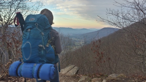
There are two trails where we were hiking. The first one is the overlook trail, which has its name for the stunning views of Harper’s Ferry from the cliffs of Maryland Heights, and the second is the Stone Fort trail, which passes through several areas used by the armies from 1861-1865. We started up the Overlook trail first, which climbs up a steep but well maintained path on the way up to the ridge before winding its way down to the cliffs. After hiking around the cliffs to find the best vantage points of the town, we started back towards the Stone Fort trail.
image

While I am a sucker for gorgeous views, I was even more excited for the second half of our trip. History fascinates me, and if I wasn’t going to school for nursing I would be going to become a history teacher. As we walked up the mountain to the ridgeline we passed informative signs that conveyed snippets about the history of the area to all who pass by them. Some talked about the tents and wood cabins that soldiers built, and some talked about the powder magazines (where the black powder was stored) or the cannons that were hauled to the top. One of the main weapons used by the yankees was the 100-lb Parrot Rifle. Sitting at the crest of the ridge, this monstrous machine hurled 100-lb cannonballs over two miles and weighed 9,400 lbs. All of the cannons were brought to their positions by the soldiers, and sometimes it took 500 of them to haul the heavy suckers up. Stop for a minute and think about that. Almost 5-tons of steel hauled up a rugged mountainside by men with ropes. Needless to say we talked about how hardy the men fighting in the war must have been, and compared it to our own experiences in the Marine Corps.
image

Walking among the remains of old forts and battlefields is something I enjoy. Knowing the history behind the area you are walking through makes the experience more interactive, and I try to place myself in the shoes of the men who were fighting. This particular war saw brothers, fathers, and neighbors fighting each other. Families were divided and decimated, with members feeling so strongly that they were willing to spill the same blood that ran through their own veins. Though many will argue over specific reasons that the War Between the States took place, I believe it can be boiled down to government taking advantage of its own citizens and putting its hands in places they do not belong.
image

History repeats itself and everything happens in cycles. As our country progresses in age, tensions are growing again because people are unable to reconcile their differences in political and moral viewpoints. Earlier today my friend brought up a great point: our country needs to unite as one again, and settle our differences in a civilized manner. If followed, our constitution outlines how our country is supposed to operate, and when change is needed there are directions (not suggestions) for that as well. We would all do well to take a look at what happened 150 years ago when our country lost its ability to operate as one united nation.
image
image
image
image

image

New Beginnings

1451866746894It’s been a while since I have written anything about a trip I’ve taken. That’s not because I haven’t been on any, I just haven’t felt like writing… oh yeah, and WordPress deleted a 1700 word post I wrote about the Roan Highlands! Since my last post I have been to New Hampshire to hike in the White Mountains and visit with family, North Carolina, Tennessee, and of course my adopted state of Virginia. This post isn’t going to be about any of those. Instead, it is going to be about my most recent trip (which happens to be the one I cherish the most).

I’m on my Christmas break from school right now and, as the days dwindle until it resumes, decided I needed to get at least one last trip in. I started scouring the internet for weather conditions in Virginia, trying to find some pleasant weather, but, despite the rather warm winter we have been having, everywhere I looked was going to be below freezing at night. This isn’t a problem for me, but I wasn’t the only person who would be going on this trip.

20160102_091725_Richtone(HDR)


On this occasion I would be bringing along a wonderful woman I have been seeing for a while. With dark hair and blue/green eyes (they change), a go-with-the-flow attitude, and a beautiful smile, she makes my heart skip a beat every time I am with her. She is beautiful inside and out. However, she has never been camping in a tent. I had to show her how wonderful it is, so of course I chose one of my favorite spots in Virginia: McAfee Knob.

20160102_073517_Richtone(HDR)

I was initially worried about the weather because she gets cold easily, and it could definitely be argued that I should have just waited… but I wanted to make a memory like this together sooner than later. Besides that, can you think of a better way to bring in the New Year? That’s a rhetorical question, don’t answer it. So I asked her if she would like to come, she said yes, and I began planning.

20160101_085722_Richtone(HDR)
I borrowed the camouflage Arc’teryx pack, and Maggie used my Osprey Atmos 50

I had to borrow a pack from my buddy, and some wool blankets, but other than that I had everything we needed. We left my house at around 10:30 a.m. and headed south to Roanoke on a, surprisingly, mostly empty I-81. 81 is notorious for being packed with 18-wheelers, who have no problem driving side by side at 20 mph under the speed limit, so that was a real blessing. We got to the Catawba Mountain parking lot on VA 311 pretty quickly, and started up the mountain at 3 p.m.

Clouds were covering most of the area we were hiking in, so it was overcast and chilly, but we still had to stop and take breaks because we were sweating. There really wasn’t a happy medium in layering and rate of travel to be comfortable while still hiking fast enough to be at the Knob for sunset. So, we marched on, and made it to the world-famous vista fifteen minutes before sunset. By then, the clouds had somewhat cleared and we were able to snag some good pictures, but we didn’t stay long. Our destination for the night was the Pig Farm campsite, .6 miles north on the Appalachian Trail.

20160101_164300_Richtone(HDR)

I really am proud of Maggie. We got to the campsite right as the final rays of light were ebbing away, and it was getting even colder. She helped me set up the tent (Big Agnes Seedhouse SL1), and then started gathering sticks to make a fire. There were really only twigs around, which don’t go far when you want to warm up, but she made several trips all around the area to find them while I set camp up and got dinner ready. I don’t want to say that this surprised me, but it sure makes me smile when I think about it.

After our attempts (with copious amounts of lighter fluid) to turn the damp twigs and leaves into a roaring fire, we decided to just eat our dinners and get in the tent. Normally I bring Mountain House meals for each meal (I still did for breakfast), because they are tried and true, but this time I went with the more expensive “Good to-go” brand and brought a Thai Curry and Herbed Mushroom Risotto. I was introduced to the Thai Curry from “Good to-go” by some friends I met while camping in the Grayson Highlands, and I think they taste a bit more like real food.

20160101_170251_Richtone(HDR)

We could hear the wind howling most of the night; it was louder than any wind I have ever camped in, and for a minute I was worried that it might collapse our tent. We were very warm though, because we probably had ten to fifteen pounds of sleeping bags and blankets under and over us. We used two sleeping pads (my closed-cell foam pad, and an inflatable pad), my Kelty 35-degree synthetic bag (which we draped over the pads and laid on), my Marmot Sawtooth 15-degree down sleeping bag (we unzipped this and used it as a quilt, with a Nalgene full of boiling water covered in a wool sock by our feet), and laid the two wool blankets over all of it. It almost felt like a summer night in the tent, we were so warm.

The next morning we got up and packed my Osprey Atmos 50 pack with some water, snacks, and the two wool blankets (it was still 25 degrees) before making the .6 mile uphill trek to the Knob again to watch the sunrise. We made it a few minutes before and were in awe once we got to the cliffs, from which we would be watching the sun make its appearance. The howling wind from the night before had removed any trace of clouds from the sky, leaving the horizon so clear that you could see the transition of colors from the dark red just visible over the mountain tops, to the deep blue of the sky.

1451861723049

I like to think that I know exactly what I’m doing, and I do most of the time, but there was one thing that really could have made the trip better. I use IsoButane fuel canisters to boil water in my JetBoil, but because of the cold the fuel would barely feed to the ignitor, and I couldn’t get the water to boil in the morning. It didn’t seem like that big of a deal, but we still had 5 miles of hiking to go before we got back to my truck, and a hot breakfast really would have been nice. My ego got put in its place, which is probably a good thing, and Maggie saved the day with the almonds and other mixed nuts (and slim jims) that she had brought.

Once we got back to the truck we made a beeline for the nearest Waffle House and gorged ourselves upon copious amounts of scrumptious, greasy food before getting back on the road. The destination for the afternoon was the Inn at Old Virginia, a beautiful and charming bed and breakfast in Staunton, Virginia. Not wanting to be on the interstate again, we elected to take back roads to Staunton since it was such a sunny day, and were rewarded with rolling hills of farmland and mountains in the background.

20160103_113916_Richtone(HDR)

The Inn is a few miles outside of Staunton, and is absolutely gorgeous. The staff there is very pleasant and helpful, and the owner is a real sweetheart of a lady. There is a main house with some rooms in it, which has a library with elegant leather-bound books in it, a dining area inside of what I think was a greenhouse, and “the barn”, which is a short walk from the main house and has been renovated with beautiful rooms. Ours even had a private porch from which we watched the sun rise in the morning again. If you are in the area and looking for a nice, romantic place to stay, I would not hesitate to recommend the Inn at Old Virginia.

20160103_074050_Richtone(HDR)
Sunrise from our private porch

After a breakfast of french toast, bacon, and a fruit bowl, we decided to drive south to the Raven’s Roost overlook on the Blue Ridge Parkway. This particular spot has been recommended to me by several people, and it is only 10 miles down the parkway, so we decided to go. It was very pretty, but I think I would rather go when it is warmer and the wind is not blowing in my face. We took our photos and then went to get back in my truck, when a car pulled up behind us. This is pretty normal, as people stop to admire the beauty of the Blue Ridge mountains at the many scenic overlooks, but a couple got out of the car and asked us to take a picture for them. I obliged, and as they walked over to the ledge and posed for the picture the lady said, “do you think we should tell them?” This really got my imagination running… Tell me what? Are you axe-murderers? Are you going to try and rob us? No, it was something much sweeter. She smiled at the man next to her, looked back at me, and said, “we just got engaged thirty minutes ago.” I’m a total romantic, so that brought about a goofy grin on my face and I started congratulating them. But my hands were numb from the cold by that point, so I took the photos and got back in the truck. It was really nice to see though, and the guy picked a perfect day to propose in the mountains.

20160103_114051_Richtone(HDR)

Driving back north, we decided to get some food and then hopped onto Skyline Drive, choosing to take the scenic route again and enjoy our time together. We talked about serious things, funny things, and took in the beauty of the mountains while heading back to Fredericksburg. Maggie isn’t afraid of silence, which I really appreciate, because sometimes it’s nice to hold hands, stare down the road and drive, and smile at each other because we are both having an amazing time. I was a little worried that she might not want to go on any more trips with me after all the cold we experienced, but she still wants to (though, maybe in warmer weather, which I agree with).


We brought the New Year in the best way I know how: sleeping in the woods and watching the sun rise in the mountains. Oh yeah, and did I mention we are in a relationship now? It’s Facebook official. I hope whoever has managed to read this novel (I promise I didn’t mean for it to be this long) started 2016 doing something they love, and in good spirits. Here’s to new beginnings.

IMG958526

Old Rag Mountain

Today a few friends and I made the trip out to Shenandoah National Park to hike Old Rag Mountain, as a farewell trip for one of my good buddies leaving the Marine Corps. Old Rag is one of the most popular hikes in Virginia. With breathtaking views and fun rock scrambles, it makes for a great day hike.

We couldn’t have asked for a more perfect day; it was sunny and sixty degrees out. Last time I went it was thirty degrees and we were sliding on ice at the higher elevations.

DCIM100GOPRO

Today was the first time I used my Go Pro, and I didn’t realize I had fat-fingered some of the pictures, so I apologize in advance. We still got some great shots.

For those of you that haven’t been to Old Rag, you must. The trail to the summit is about three and a half miles, and starts off with some switchbacks, and evolves into a boulder scramble near the top. In some parts the trail drops ten feet between two rocks, and in others you literally have to pull yourself up and over the rocks.

DCIM100GOPRO

The boulder scramble near the top can cause lines to back up as people search for sound foot and hand holds on days like today, but we arrived at two-thirty and missed all of that, leaving us free to hike and climb at our own pace most of the time.

DCIM100GOPRO

There are plenty of opportunities to pose on rocks along the way.

received_10204164488143410

On the summit with my buddy Noe, who is heading back to California this week.

DCIM100GOPRO

Once you get to the summit you are treated to gorgeous 360 degree views of the Appalachian Mountains and valleys in Shenandoah National Park. You may be tired, but if you spend a few minutes taking in the scenery (and resting your legs) you will realize that the effort was worth it.

DCIM100GOPRO

We took the fire road back down the other side of the mountain, which meets up at the base of the trail. If you do the loop like we did, the entire trip (including the walk to and from the parking lot, a short way from the trail head) is 9.3 miles.

received_10204164489623447

Jumping from rock to rock is a great way to get the adrenaline pumping, with drop offs into valleys below only a few feet away.

On the way down we passed a boy scout troop camping out at the Old Rag shelter, and saw a small snake along the path. I’m not sure what kind it was, but the back was a dull brown (almost looked like water moccasin) and it had a yellow ring around its neck.

After reaching the base of the mountain again, we all decided some Sonic was in order… After all, who doesn’t love a Cherry Limeade after an afternoon of hiking?

While losing a great friend is never fun, we got to spend one last Saturday doing one of our favorite things with good people. Live it up in California, Noe. I am looking forward to seeing pictures from the PCT!

DCIM100GOPRO

received_10204164488303414

received_10204164489303439

Roadtrip through the mountains

I hate being cooped up inside more than (almost) anything, which is part of the reason I have been bummed out all week. If you read my last post you might remember a sentence about hurting my foot a little bit. It was still hurting most of the week so I decided to stay off it, not wanting to strain it more before my hike. While eating at the chow hall Saturday morning I couldn’t stop thinking about how boring my weekend was about to be, since I wasn’t going to do anything outdoors, when a (so simple I felt stupid) thought materialized in my head: rent a car.

Lately I have been floating down the river Life, paddling a little here or there for some gentle guidance, but, mainly just going with the flow. So I decided to take an impromptu trip; it seemed like a good idea.

I showed up at the dealership after reserving a compact-class car online. I read some very good reviews about this particular location, but was slightly worried when the first thing I saw was a woman yelling at the man behind the counter. Not to worry though, because when she got on the phone the man motioned for me to step back in his office.

For two days the car was going to cost me almost two hundred dollars. Yikes. Still better than staying inside, though, so I said okay. This is when my day started to get really great. I pulled out my credit card, and the man informed me that since it was with USAA the underage fee was waived; I just saved eighty dollars because of the bank I use (note to self: stay with them). Smiling to myself, I missed what the man said after that. When I asked him to repeat it, he then told me there were no more compact cars left, but since I had reserved it online he would bump me up to a Toyota Corolla.

That idea I had in the chow hall? It was a good one.

After finishing everything up in the rental office I headed out west towards Shenandoah National Park. I didn’t do anything besides drive, but I still had a great time. I enjoy driving the back roads through the farmlands all the way to the mountains.

Lying in my bed that evening I thought to myself, “I need to do something more exciting tomorrow. I won’t have the car forever and, after all, the weather is supposed to be perfect.” So I used God’s gift to humans, Google, and searched for the best day hikes in Virginia.

I found Spy Rock, which I had already heard about, and decided to drive there the next day. I had a funny (but good feeling) about it, so I just went with it.

Sunday morning I woke up at nine, got dressed, and got in the car. The weather was immaculate; sixty-five degrees and a blue sky makes for a wonderful day of driving. I could have driven diagonally across Virginia and been at Spy Rock in a little less than two hours, but what’s the fun in that? I drove right back to Shenandoah National Park and hopped on Skyline Drive, where I would connect with Blue Ridge Parkway.

These two roadways have to be some of the best in the country. Breathtaking beauty at every turn, perfectly smooth roads and tight s-curves, the National Park Service has found the recipe for perfection and exhilarating (at least when the park rangers aren’t around…) driving. My only complaint is the speed limit of 35 MPH.

I got to the parking lot for Spy Rock after pretending I was a rally car driver on some steep and curvaceous roads full of blind turns. The road to get there was nothing but dirt and rocks; I was just hoping that I wouldn’t scratch the rental car up because it sits so low to the ground.

20150405_142850

I didn’t mess it up, thank god.

After parking, I headed up the trail, which was pretty bland for the most part; the first mile of it is on a private road made of shale, and you pass several houses.

20150405_143649

I just got over the worst part of a sinus flare up (four boxes of tissues, five nose bleeds and one cracked nose later) and I’m still coughing up phlegm, so going up the trail sucked. It wasn’t as hard as some of the reviews I read online, though they might have been penned by a few of the people I passed on the way up. A good number of people looked like they were about to have heart attacks from the strain.

After suffering a steep and boring trail you reach the top, where a huge granite slab greets you, beckoning you to climb her and feast your eyes upon 360 degrees of beautiful Virginia. When I say beautiful, I mean it. Sitting atop the rock, cradled in a perfect nook, I understood why men such as Robert E. Lee loved this state so much. The ascent may suck, but for a 1.5 mile climb Spy Rock has the best pay off of any hike I’ve been on. Hands down.

20150405_153307

After climbing back down, and carefully driving out to the main road, I remembered reading about Crabtree Falls, two miles down the road.

Insert paragraph about driving like a badass rally car driver for ten minutes (I actually passed the entrance to Crabtree Falls because I was having so much fun).

I pulled in the parking lot and asked someone the distance to the top; it was already 4:15 p.m. and I still had a four hour drive back to base. The man I asked told me it was 1.7 miles up, but “pretty f***ing steep”. I started making excuses and said I had to drive back to Quantico. Mistake. He put a guilt trip on me and said if his old ass could do it a Marine can too.

I’m glad he did. If I had gone back and googled Crabtree Falls I would have punched myself for not going. It is gorgeous.

IMG_20150405_223420

The first view is a mere 500 feet from the parking lot, and from the looks of it, most people don’t make it past there. All the better, because I am not a fan of crowded trails.

If you hate stairs like I do, this may not be the trail for you…it starts with several sets. Fortunately, it gets better and the trail reappears, mainly with rocks.

The trail is never too far away from the falls, thanks to the fact that they tumble down 1200 feet in several separate sections, most with an area to stop and snap some pictures. A few people who are more adventurous will hop from rock to rock across the river, and hope they don’t fall in the water and go over the falls, because they just have to get the best picture.

IMG_20150405_223527

Half way up I passed a family of five, all wearing Crocs. I felt sorry for the kids, because with all the small rocks on the trail that could get in a shoe, that can’t have been comfortable. I don’t have kids, but when I do I will make sure they are prepared for activities like hiking and have the proper footwear (because I’ll be damned if they sit inside and play video games all day). I think the parents figured out, eventually, that they were not prepared and were just hanging out around a view point; on the way down I saw one of the kids making a Zen rock garden that I forgot to take a picture of.

Once getting to the top I realized I had completely forgot about my foot when starting out at Spy Rock, but it also didn’t hurt. Pleased, I decided to run back down. There is nothing like hearing people mutter about you doing something because they can’t do it. It gives me motivation.

Despite going faster on the descent, I still caught a few things I passed by without noticing before, most notably a cave.

20150405_164248

After doing some more rally car driving, I wound my way back to Blue Ridge Parkway for twenty-five miles, and Skyline Drive for seventy-three more.

Dusk in Shenandoah National Park is pretty magical. All the wildlife you don’t see (for the most part) during the day comes out to play. I saw a few turkey, an opossum and about 100 deer. The number of deer was the part that was different, because these guys are not really scared of you in the daylight either. Driving down the road you can see plenty.

20150405_132610

After a day of driving and hiking, I finally slowed my pace and my thoughts to watch the sunset. If you haven’t before, a sunset in the mountains is nothing short of amazing; there is no way to describe how you feel as the sun descends beyond them, with an almost mournful, red center, branching out in pinks and oranges. Pictures do not do them justice.

IMG_20150405_223214

I finally got back to my barracks room, showered, ate and hopped in bed, when I noticed this:

20150405_225136

I’ve had a thousand sunburns before, and I reckon I have another few thousand left if I can go on half of the adventures my crazy mind churns out.

From the very top of Crabtree Falls

C&O Canal Towpath

received_10204083601041283

A few weeks ago one of the guys I hike with regularly suggested that we hike the Chesapeake and Ohio Canal Towpath from Harper’s Ferry, West Virginia to Washington, D.C. The path follows an old canal that was used to ferry freight on boats and rafts around the eastern portion of the country, sometimes using teams of horse buggies on either side to pull it. Today the path exists mainly on one side of the canal, which is overgrown in parts, and is relatively flat, which makes for a pleasant walk through nature.

The portion we hiked runs for sixty miles. We checked the weather throughout the week and it appeared to be perfect; forty to fifty degree temperatures and clear skies. We got the clear skies part, but the temperatures were mainly in the thirties.

Friday night we arrived at Harper’s Ferry and began our hike at 7:30 p.m., passing by old locks and following the Shenandoah River, finally making camp at around 11:00 p.m. after ten miles of night hiking.

20150327_193846

We saw a few signs on the way advertising a family campground and decided it would be a good place to stop for the night, but when we arrived it looked more like a run down trailer park, with old military tents in half ruin set up in a hodge podge fashion. Deciding it was not what we were comfortable with, we kept moving until we found the first official camp ground on the path.

The camp ground looked promising. Right next to the river, with soft soil and a clear sky, we pitched our tents. It was cold and we were fumbling while setting up the tents, so I decided to half heartedly throw the rain fly over my Big Agnes tent.

Big mistake.

A few hours after sliding into my sleeping bag the wind picked up and it got even colder. My sleeping bag is rated at thirty-five degrees, and it was in the low twenties. After a night of shivering from the wind blowing inside, and tossing and turning while I searched for a warm position, I grudgingly got up.

The first three hours of the day were pretty miserable. Living in south Texas for most of my life, I used to think I liked the cold (which I considered to be fifty degrees). After living in Virginia for a year I have discovered what cold is and I can safely say it sucks.

The whole time I was walking that morning I kept thinking of a day when I was riding around with my uncle at his ranch. I had mentioned that I love the cold, and he said he hated it. When I asked him why, he replied, “I used to like the cold too, until I had to work in it. After sitting on a horse in the freezing rain for hours, you learn to hate it.” Luckily it wasn’t raining, but I’ve been stuck outside in that type of weather here in Virginia, and I am definitely in the cold-hating group now.

The whole day wasn’t bad though. After a few hours it warmed up, and I thoroughly enjoyed walking the path along the canal. We got to see some of the locks that still work, despite their age, plenty of people biking the path, and even a few hearty souls running marathon type mileage out there (willingly!) Later in the afternoon we passed a power plant and a kayak course in one of their drainage ditches (not sure I’d want to get in that water).

20150329_08265120150328_115821

We also saw some tasty-looking road kill further down the path.

20150328_134448

We had planned on doing thirty-five miles that day, but my foot started to hurt and had to cut it to thirty. I thought maybe it was because my laces were too tight, so I loosened them a bit, but it didn’t help. There is a bruise on the top left portion of my right foot now, and I’m hoping it is just an overuse strain or something similar.

received_10204083603241338

The distance on the app was messed up because of the added weight of a pack, but we took over seventy thousand steps that day.

After hitting our thirty mile mark we really only wanted to set up camp since night was fast approaching. After passing miles of path bordered only by the Potomac River, we struck luck and found a path leading to a wooded area by the river ten yards after the mile marker. We quickly pitched our tents, got situated, and pulled out my Jetboil for some hot beef stroganoff and chili mac that my friend brought. After a long day of hiking, and a cold night ahead, hot food can do wonders for your morale.

Once again the temperatures dropped significantly lower than our sleeping bags were rated for, but we were prepared this time. We staked our rain flys down with great care, and despite it being 21 degrees when we awoke, we stayed warm.

20150329_081616

Our view this morning upon waking up.

We kicked the day off earlier and were on the trail by eight a.m. The weather was much kinder, and though it was colder, there was minimal wind. We were just past Seneca Falls, and within a few hours were in Great Falls State Park.

I had been in the park before, but on the other side where most of the “best views” are. That side has better views if you are looking for the falls, but the side we chose did not disappoint. The path followed wide and calm water for miles, and there were plenty of folks enjoying the beautiful, forty-something degree weather on foot and bike; we even passed a group of about twenty kids riding their bikes.

20150329_104622received_10204083604241363

Despite having a great time, I will say that pleasantries are a lost cause for much of the D.C. area. The park is only a short drive from the city, so that is where most of the people are from who visit it. Gentlemen that we are, we said “good morning” or “how’s it going” to everyone we passed by, and about half would either keep walking without acknowledging we had said anything, or looking at us and then back to whatever they were looking at before. It’s not like I was talking to hear myself! I suppose people are just raised differently here than back home.

Normally there are plenty of water fountains and pumps spread out along the trail, but they are turned off throughout winter (and apparently part of spring) until April fifteenth, so if you decide to do the trail plan accordingly. That didn’t stop us from trying each one, but it did make us disgruntled, as we had reached the last drops of our water supply. With ten miles left to Washington, we finally came upon a kayak rental and bought water bottles. What a god send. Dehydrated from the wind and Sun, we filled our camelbacks and pressed on.

The last ten miles literally felt like a death march. Our feet were sore and tired (but had no blisters, thanks to a combination of Injinji toe sock liners and SmartWool sock) from putting so many miles on them in a short time, and our legs were tired.

While the trip beat staying in the barracks all weekend, and I had a blast walking through the woods, I think that if I ever do this trail again it will be drawn out longer. We ended up doing twenty miles to Washington on our last day, in pain for half of it, and pushing the envelope on how much time we had left. However, crossing the bridge at the end was awesome. Standing over the river and seeing the Washington monument in the distance, knowing that you have just walked sixty miles with a pack in a two days, is so rewarding. I would recommend this walk to anyone.

20150329_153156

received_10204083604041358

Mileage was more like twenty two miles the last day, but the forty-nine thousand steps is accurate, for a total of over 120,000 steps on the trip.

20150328_114948

There was a lockhouse like this at every lock.

20150328_135540

Remains of a lock.

Shenandoah National Park

received_10203991144449926

My birthday is tomorrow, and since it is on a Monday two friends and I decided to go on a hike today.

Shenandoah National Park is my go-to location anytime I want to get some beautiful hiking in, and she didn’t fail us today! Having done Old Rag before, we wanted something new, and I stumbled upon a blog posting about a circuit hike of White Oak Canyon trail and Cedar Run, with a summit of Hawksbill Mountain in the middle, for a total of twelve miles.

received_10203991144489927

The place was gorgeous. We passed seven waterfalls along the way, got blasted by the wind at the summit, and hiked alongside a beautiful mountain stream for around half the trip.

We began on White Oak Canyon trail at 9:15 am, and were soon hiking up steep switchback sections. This wasn’t a problem, but I suck at pacing myself and one of the guys hiking was really fast, so I was a bit winded for a while. No pain no gain though, right?

The weather couldn’t have been better; it was sunny and around 50 degrees for most of the hike, and it had rained all day on Saturday, beefing up the creeks for some nice breaks disguised as photo ops.

received_10203991164330423

Once we reached the end of the first trail we crossed Skyline Drive (if you get the chance to drive this road I highly suggest it; it follows the ridgeline of the mountains in Shenandoah and couples with Blue Ridge Parkway in the south) and got on the Appalachian Trail heading towards Hawksbill Mountain, the highest point in Shenandoah National Park. Gaining elevation, we began to see some snow on the side of the trail and eventually encountered about a quarter to a half mile section of trail covered in ice. This was not the thin ice that your body weight will crunch through and give you traction; we probably could have skated on it (and accidentally did on a few parts).

IMG_20150315_155455

After revelling in the view at the summit we began our descent. Knee jarring is probably a good way to describe it, without the expletives we uttered every few steps. The trail down the mountain quickly became very steep and we were half jogging portions of it. Some people were dragging or carrying young kids up as we went down, and they didn’t look very happy.

IMG_20150315_155214

Once we got down we crossed Skyline Drive again and headed onto the Cedar Run trail. The trail was pretty rocky at first, but not too steep. We all almost fell a few times, but didn’t, because we are ninjas. About three quarters of a mile down the trail we came across a couple. Most people we passed along the trail were very cheerful and waved as we crossed paths, but not these two. It might have something to do with the fact that  the lady was scrambling to pull her pants on as we approached!

received_10203991162530378

After swapping jokes about what we had just seen, the dry creek bed the trail had been mirroring began to spring to life. As we wound our way down the mountainside and into the canyon, the scenery began to get even more beautiful. Cascading falls, fallen trees crisscrossing the stream and the blue-green water mesmerized me. Of course, beauty comes with a price, and the descent started to get tough as shit with the rocks and steepness of the trail. If we had stopped at every place that presented an opportunity for a great picture we would probably still be on the trail right now.

IMG_20150315_155006

I wasn’t going to bring an ace wrap on my thru hike (because I’m a ninja, remember?), but I decided I probably should. My buddy twisted his ankle a few times on the steep, rocky sections, and we were lucky I had brought my trekking poles so he could use them as support.

IMG_20150315_160535

Overall it was a very fun adventure and only took us five hours. We are planning on doing a trail that runs along an old canal for seventy miles from Harper’s Ferry to Washington, D.C. in a few weeks, and one of my friends is going to take leave and hike a portion of Virginia with me when I am doing my thru hike.